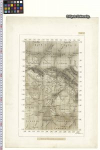
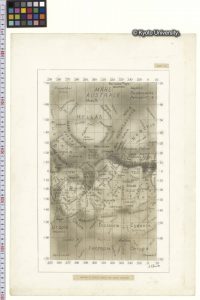
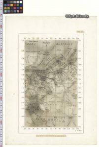
Maps of Mars by Shiro Ebisawa, 1957−1959.
Shiro Ebisawa created detailed maps of Mars by organizing the results of visible and photo observations obtained between 1907 to 1956 by observers in various nations, and results of visible observations by himself. The maps are drawn on three drawing papers; each one is about 40 centimeters by 20 centimeters. They contain conventional names and names that were originated by Ebisawa besides. Ebisawa Maps were used by observers of Mars around the world as one of the most detailed maps of Mars, and were appreciated internationally.
- Date
1957–1959 - Extent
3 drawing papers with backing papers - Name of Creator(s)
Shiro Ebisawa; Kwasan and Hida Observatories, Graduate School of Science, Kyoto University - Existence and Location of Copies
4 metadata records - Archivist and Date
2012